Custom Chart of Grand Haven – NOAA Nautical Chart 40″ x 60″ (Vertical)

$124.95

Custom nautical chart of Grand Haven on rolled poster. Official NOAA data. Free shipping.

Chart Type: Custom Nautical Chart
Chart Title: Custom Chart of Grand Haven
Free Shipping
30-Day Returns
Official NOAA Data
Greenguard Gold Inks

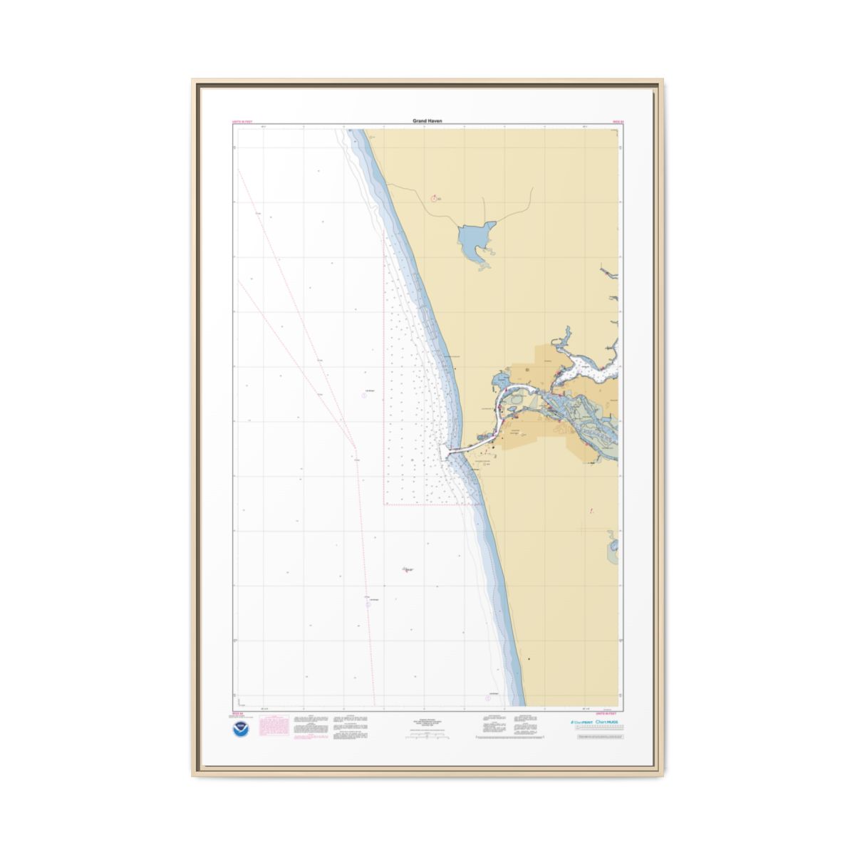
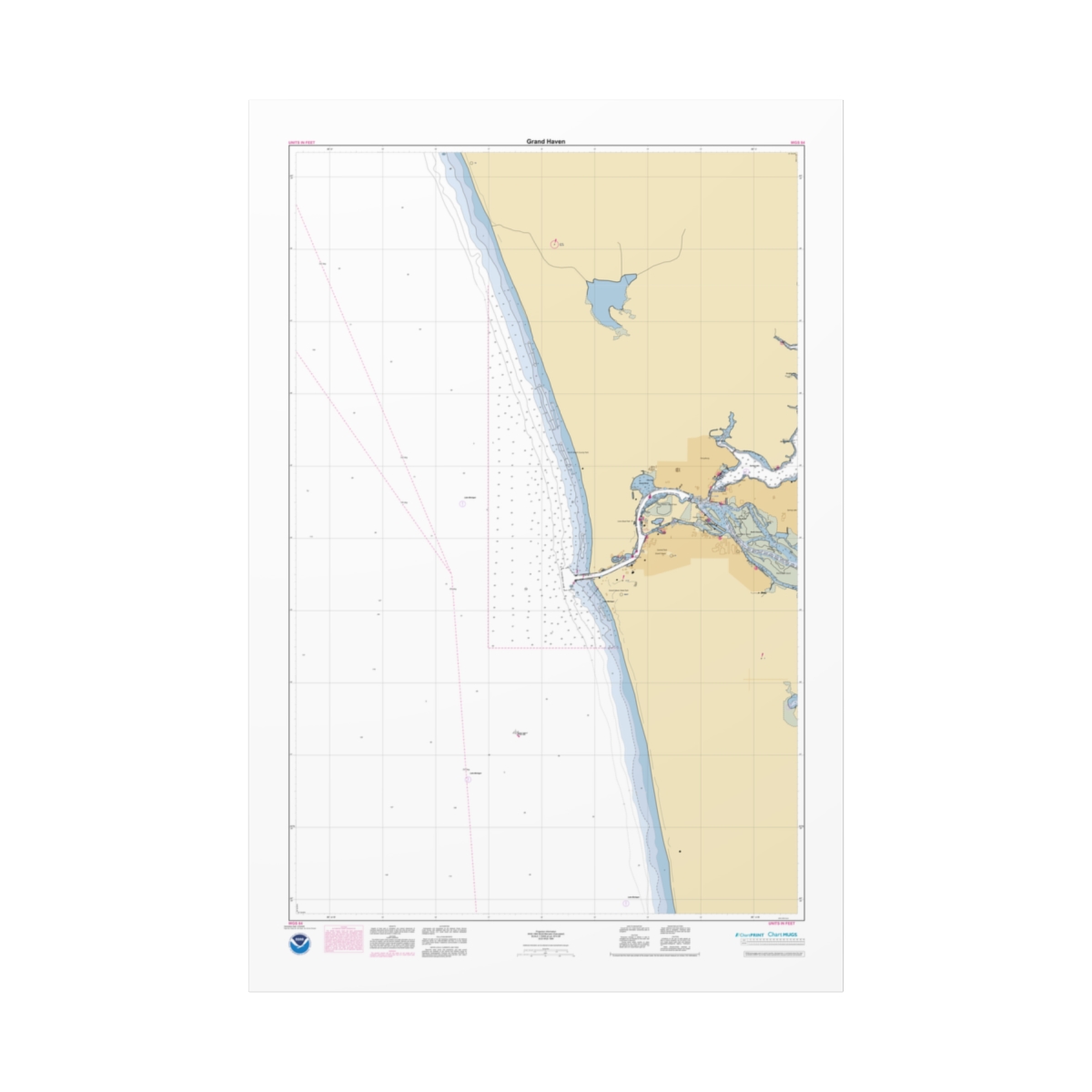
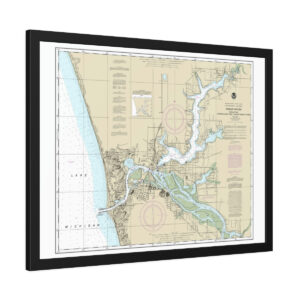
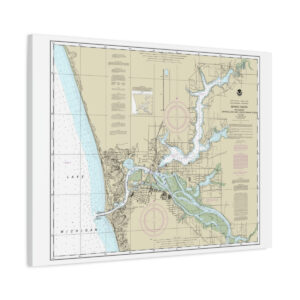
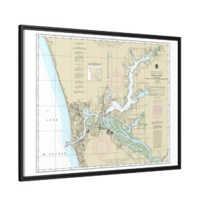
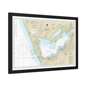
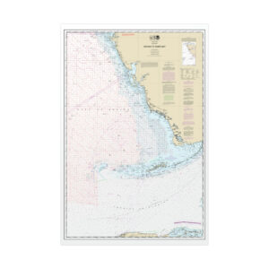
Grand Haven Custom Nautical Chart

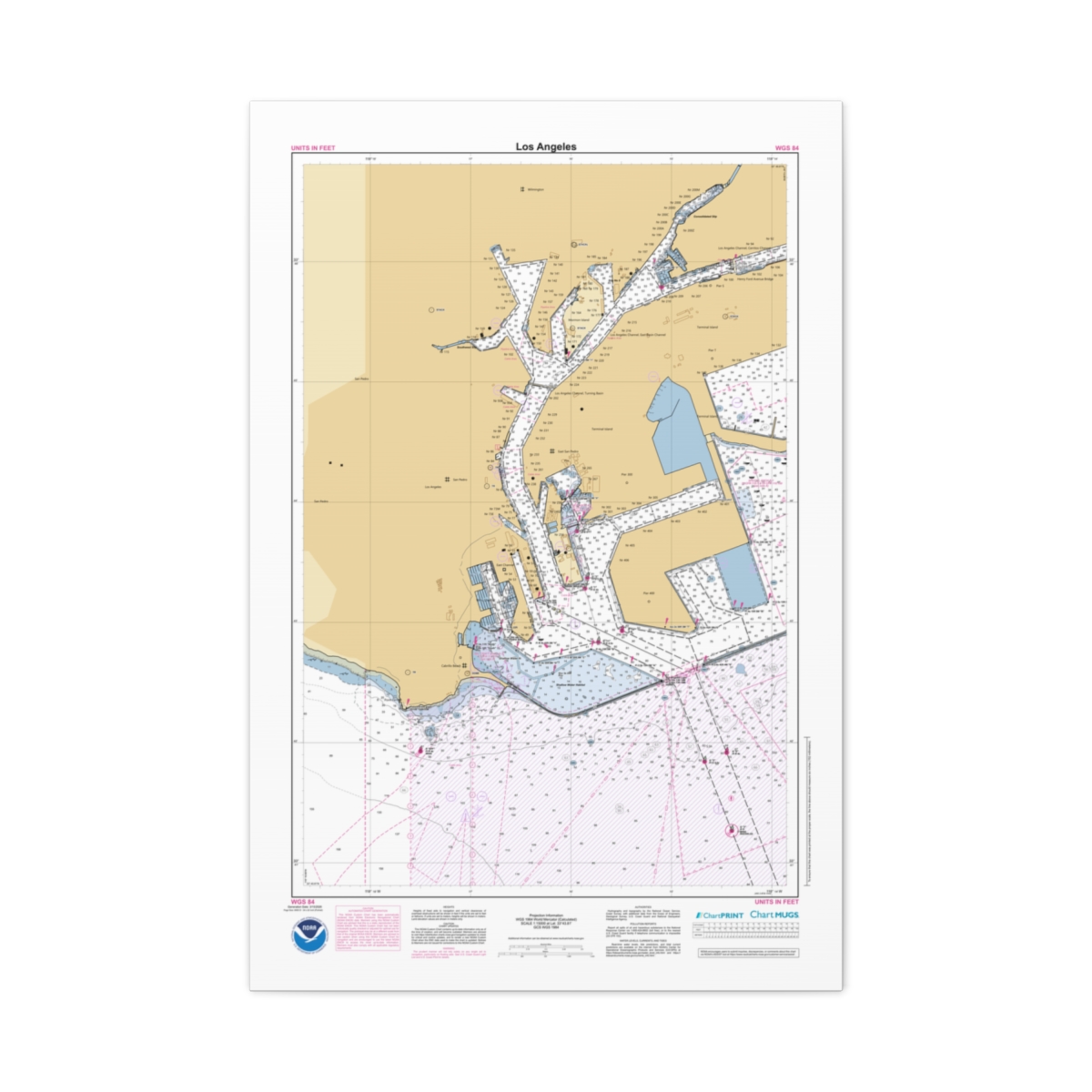
Personalized nautical chart of Grand Haven at 1:15,000 scale — built from the same NOAA Electronic Navigational Chart data used in real marine navigation. A working-distance view of Grand Haven showing harbor entrances, navigation channels, and the coastal waters just offshore. 40″ x 60″ (Vertical).

Premium Print

Your Grand Haven Nautical Chart Poster

This Grand Haven nautical chart poster is a giclée reproduction on your choice of two premium paper finishes — matte for a clean non-reflective surface, or satin for a subtle sheen with vivid color fidelity. Every depth sounding, channel marker, and contour line from the NOAA ENC data comes through with sharp precision at this large format size. Ships rolled in a protective tube.

Two Options

Choose Your Paper

Matte paper for Grand Haven nautical chart poster

Matte

Clean, non-reflective surface. Classic look for large format charts.

Satin paper for Grand Haven chart

Satin

Subtle sheen with vivid color fidelity. Bright, sharp chart detail.

Print Quality

Sunlight-Resistant Giclée Print

The giclée process delivers rich color that holds up over time, even in sunlit rooms. Fine linework, depth contours, and navigation symbology all print with the precision the original ENC data demands.

Giclée Print

Sunlight-resistant inks that won’t fade over time

Three Papers

Fine art, semi-glossy, or matte finish

Protective Tube

Ships rolled in a cardboard shipping tube

Free Shipping

Every order ships free within the US

Grand Haven nautical chart poster hanging with clipsChart poster shipped rolled in protective tube
Chart Data

Built from Current NOAA ENC Data

Every line, sounding, and symbol comes from official NOAA ENC data — the modern vector-based format that replaced the retired Raster Nautical Chart series. A piece of coastal wall art built to last.

  • Chart Source: Official NOAA ENC data
  • Scale: 1:15,000 — approach detail
  • Print Size: 40″ x 60″ (Vertical)
  • Format: Rolled Poster
  • Paper: Three options — matte or satin
  • Print: Giclée — sunlight-resistant inks
  • Shipping: Free on all orders

FAQ

Questions & Answers

Which paper should I choose?
Fine art has a soft textured surface like traditional watercolor paper — best for a classic, archival feel. Semi-glossy is a bright white satin photo paper with sharp color — great for vivid charts. Matte is lighter weight with a non-reflective surface, ideal for framing behind glass.
How does the poster ship?
Rolled in a protective cardboard shipping tube. Unroll it and take it to your preferred framer, or hang it with poster clips.
Will the colors fade?
Our giclée inks resist fading from regular sunlight exposure. For maximum longevity, avoid prolonged direct sun.
Is this chart suitable for navigation?
Our charts use official NOAA data but are designed as premium wall art, not for active navigation. For navigation, use NOAA’s digital chart tools or approved electronic chart systems.

If the print gathers dust, wipe gently with a clean, dry cloth.

Design Your Own Chart

Create another custom nautical chart from any US waterway using the latest NOAA ENC data.

Open the Chart Builder

Chart Notes Preview

Grand Haven

Generation Date: 3/16/2026

Page 2

NOAA CUSTOM CHART

NOTES GEOSPATIAL DATABASE

VERSION 3.0B - 20 FEBRUARY 2025

The records of the NOAA Custom

Chart Notes Geospatial Database are

current as of February 20, 2025.

Subsequent additions and refinements

are to be expected. Please refer to

all

available

navigational

publications for complete information

about the charted area.

CAUTION

AUTOMATED CHART GENERATION

This NOAA Custom Chart has been

automatically

rendered

from

NOAA

Electronic Navigational Chart (NOAA

ENC®) data. Mariners using this NOAA

Custom Chart are advised that this is

a static reproduction of the NOAA

ENC®. This NOAA Custom Chart has not

been individually quality checked or

adjusted

for

optimal

use

for

navigation. The portrayal may be at a

different scale from that of the

original NOAA ENC®. Mariners are

advised to use caution when using

this NOAA Custom Chart for navigation

and are encouraged to use the latest

NOAA ENC® to access the most up-to-

date information. Mariners must also

comply with all applicable regulatory

requirements.

CAUTION

CHART UPDATES

This NOAA Custom Chart contains up-

to-date information only as of the

time of creation, and will become

outdated. Mariners are advised to

visit

https://

distribution.charts.noaa.gov/

navigation-updates/

to

check

for

critical and routine updates, and to

render a new NOAA Custom Chart when

the ENC data used to make the chart

is updated. Notices to Mariners are

not issued for corrections to this

NOAA Custom Chart.

HEIGHTS

Heights of fixed aids to navigation

and vertical clearances of overhead

obstructions will be shown in feet if

the units are set to feet or fathoms.

If units are set to meters, heights

will

be

shown

in

meters.

Land

elevation values are shown in meters

only.

AUTHORITIES

Hydrography and topography by the

National Ocean Service, Coast Survey,

with additional data from the Corps

of Engineers, Geological Survey, U.S.

Coast Guard and National Geospatial-

Intelligence Agency.

WATER LEVELS, CURRENTS, AND TIDES

Real-time

water

levels,

tide

predictions,

and

tidal

current

predictions are available on the

internet

from

NOAA’s

Center

for

Operational

Oceanographic

Products

and Services (CO-OPS) at https://

tidesandcurrents.noaa.gov/

water_level_info.html

and

https://

tidesandcurrents.noaa.gov/

currents_info.html .

COMMENTS REQUESTED

NOAA encourages users to submit

inquiries, discrepancies, or comments

about this chart via NOAA's ASSIST

tool

at

https://

nauticalcharts.noaa.gov/customer-

service/assist/ .

ABBREVIATIONS

For complete list of Symbols and

Abbreviations, see Chart No. 1.

Grand Haven

Generation Date: 3/16/2026

Page 3

POLLUTION REPORTS

Report all spills of oil and

hazardous substances to the National

Response Center via 1-800-424-8802

(toll free), or to the nearest U.S.

Coast Guard facility if telephone

communication is impossible (33 CFR

153).

AIDS TO NAVIGATION

Consult U.S. Coast Guard Light List

for

supplemental

information

concerning aids to navigation.

RADAR REFLECTORS

Radar reflectors have been placed

on many floating aids to navigation.

Individual

radar

reflector

identification on these aids has been

omitted from this chart.

WARNING

The prudent mariner will not rely

solely

on

any

single

aid

to

navigation, particularly on floating

aids. See U.S. Coast Guard Light List

and U.S. Coast Pilot for details.

ADDITIONAL INFORMATION

Additional information can be

obtained

at

www.nauticalcharts.noaa.gov

SUPPLEMENTAL INFORMATION

Consult U.S. Coast Pilot 6 for

important supplemental information.

Refer to charted regulation section

numbers.

SOUNDING DATUM

Soundings in Lake Michigan are

referred to Low Water Datum, which is

577.5 feet / 176.0 meters above Mean

Water Level at Rimouski, Quebec, the

International Great Lakes Datum 1985

(IGLD 1985) reference point.

VERTICAL DATUM

Overhead clearances in the Great

Lakes

are

reduced

correspondingly

when water surface is above Low Water

Datum. See U.S. Coast Pilot 6 for

clearances.

NOTE A

Navigation

regulations

are

published in Chapter 2, U.S. Coast

Pilot 6. Additions or revisions to

Chapter

2

are

published

in

the

Notices

to

Mariners.

Information

concerning the regulations may be

obtained

at

the

Office

of

the

Commander, 9th Coast Guard District

in Cleveland, OH or at the Office of

the

District

Engineer,

Corps

of

Engineers in Detroit, MI.

Refer to charted regulation section

numbers.

SAILING COURSES

Sailing courses and limits are

recommended by the Lake Carriers

Association

and

the

Canadian

Shipowners Association.

SAILING DIRECTIONS

Bearings of sailing courses are

true and distances given thereon are

in statute miles between points of

departure.

Grand Haven

Generation Date: 3/16/2026

Page 4

CAUTION

LIMITATIONS ON THE

USE OF RADIO SIGNALS

Limitations on the use of radio

signals as aids to marine navigation

can be found in the U.S. Coast Guard

Light Lists and National Geospatial-

Intelligence Agency Publication 117.

Radio direction-finder bearings to

commercial broadcasting stations are

subject to error and should be used

with caution.

CAUTION

BASCULE BRIDGES

For bascule bridges, whose spans do

not open to a full upright or

vertical position, unlimited vertical

clearance is not available for the

entire charted horizontal clearance.

CAUTION

SUBMERGED CABLES AND PIPELINES

Additional uncharted submarine

pipelines and submarine cables may

exist within the area of this chart.

Not

all

submarine

pipelines

and

submarine cables are required to be

buried,

and

those

that

were

originally buried may have become

exposed. Mariners should use extreme

caution when operating vessels in

depths of water comparable to their

draft in areas where pipelines and

cables may exist, and when anchoring,

dragging or trawling.

Covered wells may be marked by

lighted or unlighted buoys.

CAUTION

POTABLE WATER INTAKE

Vessels operating in fresh water

lakes or rivers shall not discharge

sewage, or ballast, or bilge water

within

such

areas

adjacent

to

domestic

water

intakes

as

are

designated by the Commissioner of

Food and Drugs (21 CFR 1250.93).

Consult

U.S.

Coast

Pilot

6

for

important supplemental information.

CAUTION

Due

to

periodic

high

water

conditions, in the Great Lakes, some

features charted as visible at Low

Water

Datum

may

be

submerged,

particularly in the near shore areas.

Mariners should proceed with caution.

CAUTION

AIDS TO NAVIGATION

Aids upstream of the Grand Haven-

Ferrysburg Bridge may be relocated as

necessary without prior notice to

mark deep water outside the channel

limits.

CAUTION

USACE conducts hydrographic surveys

to

monitor

navigation

conditions.

These surveys are not intended to

detect underwater features. Uncharted

features

hazardous

to

surface

navigation are not expected but may

exist in federal channels. For more

information

visit

https://

navigation.usace.army.mil/Survey/

Hydro.

CAUTION

Temporary changes or defects in

aids to navigation are not indicated

on this chart. See Local Notice to

Mariners.

During some winter months or when

endangered by ice, certain aids to

navigation are replaced by other

types or removed. For details, see

U.S. Coast Guard Light List.

Grand Haven

Generation Date: 3/16/2026

Page 5

NOTE Z

NO-DISCHARGE ZONE, 40 CFR 140

Michigan waters of Lakes Michigan,

Huron, Superior, Erie and St. Clair,

all waterways connected thereto, and

all inland lakes are designated as a

No-Discharge Zone (NDZ). Under the

Clean Water Act, Section 312, all

vessels

operating

within

a

No-

Discharge Zone (NDZ) are completely

prohibted

from

discharging

any

sewage, treated or untreated, into

the waters. Commercial vessel sewage

shall include graywater. All vessels

with an installed marine sanitation

device (MSD) that are navigating,

moored, anchored, or docked within a

NDZ must have the MSD disabled to

prevent the overboard discharge of

sewage (treated or untreated) or

install a holding tank. Regulations

for the NDZ are contained in the U.S.

Coast Pilot. Additional information

concerning

the

regulations

and

requirements may be obtained from the

Environmental Protection Agency (EPA)

website: https://www.epa.gov/vessels-

marinas-and-ports .

GRAND HAVEN CHANNEL AIDS

Aids upstream of the Grand Haven-

Ferrysburg Bridge may be relocated as

necessary without prior notice to

mark deep water outside the channel

limits.

NOAA WEATHER RADIO BROADCASTS

The NOAA Weather Radio station

listed

below

provides

continuous

weather

broadcasts.

The

reception

range is typically 20 to 40 nautical

miles from the antenna site, but can

be as much as 100 nautical miles for

stations at high elevations.

Hesperia, MI WWF-36 162.475 MHz

NOAA WEATHER RADIO BROADCASTS

The NOAA Weather Radio station

listed

below

provides

continuous

weather

broadcasts.

The

reception

range is typically 20 to 40 nautical

miles from the antenna site, but can

be as much as 100 nautical miles for

stations at high elevations.

West Olive, MI WXN-99 162.425 MHz

Additional information

Chart Type

Chart Title

Grand Haven

Generation Date: 3/16/2026

Page 2

NOAA CUSTOM CHART

NOTES GEOSPATIAL DATABASE

VERSION 3.0B - 20 FEBRUARY 2025

The records of the NOAA Custom

Chart Notes Geospatial Database are

current as of February 20, 2025.

Subsequent additions and refinements

are to be expected. Please refer to

all

available

navigational

publications for complete information

about the charted area.

CAUTION

AUTOMATED CHART GENERATION

This NOAA Custom Chart has been

automatically

rendered

from

NOAA

Electronic Navigational Chart (NOAA

ENC®) data. Mariners using this NOAA

Custom Chart are advised that this is

a static reproduction of the NOAA

ENC®. This NOAA Custom Chart has not

been individually quality checked or

adjusted

for

optimal

use

for

navigation. The portrayal may be at a

different scale from that of the

original NOAA ENC®. Mariners are

advised to use caution when using

this NOAA Custom Chart for navigation

and are encouraged to use the latest

NOAA ENC® to access the most up-to-

date information. Mariners must also

comply with all applicable regulatory

requirements.

CAUTION

CHART UPDATES

This NOAA Custom Chart contains up-

to-date information only as of the

time of creation, and will become

outdated. Mariners are advised to

visit

https://

distribution.charts.noaa.gov/

navigation-updates/

to

check

for

critical and routine updates, and to

render a new NOAA Custom Chart when

the ENC data used to make the chart

is updated. Notices to Mariners are

not issued for corrections to this

NOAA Custom Chart.

HEIGHTS

Heights of fixed aids to navigation

and vertical clearances of overhead

obstructions will be shown in feet if

the units are set to feet or fathoms.

If units are set to meters, heights

will

be

shown

in

meters.

Land

elevation values are shown in meters

only.

AUTHORITIES

Hydrography and topography by the

National Ocean Service, Coast Survey,

with additional data from the Corps

of Engineers, Geological Survey, U.S.

Coast Guard and National Geospatial-

Intelligence Agency.

WATER LEVELS, CURRENTS, AND TIDES

Real-time

water

levels,

tide

predictions,

and

tidal

current

predictions are available on the

internet

from

NOAA’s

Center

for

Operational

Oceanographic

Products

and Services (CO-OPS) at https://

tidesandcurrents.noaa.gov/

water_level_info.html

and

https://

tidesandcurrents.noaa.gov/

currents_info.html .

COMMENTS REQUESTED

NOAA encourages users to submit

inquiries, discrepancies, or comments

about this chart via NOAA's ASSIST

tool

at

https://

nauticalcharts.noaa.gov/customer-

service/assist/ .

ABBREVIATIONS

For complete list of Symbols and

Abbreviations, see Chart No. 1.

Grand Haven

Generation Date: 3/16/2026

Page 3

POLLUTION REPORTS

Report all spills of oil and

hazardous substances to the National

Response Center via 1-800-424-8802

(toll free), or to the nearest U.S.

Coast Guard facility if telephone

communication is impossible (33 CFR

153).

AIDS TO NAVIGATION

Consult U.S. Coast Guard Light List

for

supplemental

information

concerning aids to navigation.

RADAR REFLECTORS

Radar reflectors have been placed

on many floating aids to navigation.

Individual

radar

reflector

identification on these aids has been

omitted from this chart.

WARNING

The prudent mariner will not rely

solely

on

any

single

aid

to

navigation, particularly on floating

aids. See U.S. Coast Guard Light List

and U.S. Coast Pilot for details.

ADDITIONAL INFORMATION

Additional information can be

obtained

at

www.nauticalcharts.noaa.gov

SUPPLEMENTAL INFORMATION

Consult U.S. Coast Pilot 6 for

important supplemental information.

Refer to charted regulation section

numbers.

SOUNDING DATUM

Soundings in Lake Michigan are

referred to Low Water Datum, which is

577.5 feet / 176.0 meters above Mean

Water Level at Rimouski, Quebec, the

International Great Lakes Datum 1985

(IGLD 1985) reference point.

VERTICAL DATUM

Overhead clearances in the Great

Lakes

are

reduced

correspondingly

when water surface is above Low Water

Datum. See U.S. Coast Pilot 6 for

clearances.

NOTE A

Navigation

regulations

are

published in Chapter 2, U.S. Coast

Pilot 6. Additions or revisions to

Chapter

2

are

published

in

the

Notices

to

Mariners.

Information

concerning the regulations may be

obtained

at

the

Office

of

the

Commander, 9th Coast Guard District

in Cleveland, OH or at the Office of

the

District

Engineer,

Corps

of

Engineers in Detroit, MI.

Refer to charted regulation section

numbers.

SAILING COURSES

Sailing courses and limits are

recommended by the Lake Carriers

Association

and

the

Canadian

Shipowners Association.

SAILING DIRECTIONS

Bearings of sailing courses are

true and distances given thereon are

in statute miles between points of

departure.

Grand Haven

Generation Date: 3/16/2026

Page 4

CAUTION

LIMITATIONS ON THE

USE OF RADIO SIGNALS

Limitations on the use of radio

signals as aids to marine navigation

can be found in the U.S. Coast Guard

Light Lists and National Geospatial-

Intelligence Agency Publication 117.

Radio direction-finder bearings to

commercial broadcasting stations are

subject to error and should be used

with caution.

CAUTION

BASCULE BRIDGES

For bascule bridges, whose spans do

not open to a full upright or

vertical position, unlimited vertical

clearance is not available for the

entire charted horizontal clearance.

CAUTION

SUBMERGED CABLES AND PIPELINES

Additional uncharted submarine

pipelines and submarine cables may

exist within the area of this chart.

Not

all

submarine

pipelines

and

submarine cables are required to be

buried,

and

those

that

were

originally buried may have become

exposed. Mariners should use extreme

caution when operating vessels in

depths of water comparable to their

draft in areas where pipelines and

cables may exist, and when anchoring,

dragging or trawling.

Covered wells may be marked by

lighted or unlighted buoys.

CAUTION

POTABLE WATER INTAKE

Vessels operating in fresh water

lakes or rivers shall not discharge

sewage, or ballast, or bilge water

within

such

areas

adjacent

to

domestic

water

intakes

as

are

designated by the Commissioner of

Food and Drugs (21 CFR 1250.93).

Consult

U.S.

Coast

Pilot

6

for

important supplemental information.

CAUTION

Due

to

periodic

high

water

conditions, in the Great Lakes, some

features charted as visible at Low

Water

Datum

may

be

submerged,

particularly in the near shore areas.

Mariners should proceed with caution.

CAUTION

AIDS TO NAVIGATION

Aids upstream of the Grand Haven-

Ferrysburg Bridge may be relocated as

necessary without prior notice to

mark deep water outside the channel

limits.

CAUTION

USACE conducts hydrographic surveys

to

monitor

navigation

conditions.

These surveys are not intended to

detect underwater features. Uncharted

features

hazardous

to

surface

navigation are not expected but may

exist in federal channels. For more

information

visit

https://

navigation.usace.army.mil/Survey/

Hydro.

CAUTION

Temporary changes or defects in

aids to navigation are not indicated

on this chart. See Local Notice to

Mariners.

During some winter months or when

endangered by ice, certain aids to

navigation are replaced by other

types or removed. For details, see

U.S. Coast Guard Light List.

Grand Haven

Generation Date: 3/16/2026

Page 5

NOTE Z

NO-DISCHARGE ZONE, 40 CFR 140

Michigan waters of Lakes Michigan,

Huron, Superior, Erie and St. Clair,

all waterways connected thereto, and

all inland lakes are designated as a

No-Discharge Zone (NDZ). Under the

Clean Water Act, Section 312, all

vessels

operating

within

a

No-

Discharge Zone (NDZ) are completely

prohibted

from

discharging

any

sewage, treated or untreated, into

the waters. Commercial vessel sewage

shall include graywater. All vessels

with an installed marine sanitation

device (MSD) that are navigating,

moored, anchored, or docked within a

NDZ must have the MSD disabled to

prevent the overboard discharge of

sewage (treated or untreated) or

install a holding tank. Regulations

for the NDZ are contained in the U.S.

Coast Pilot. Additional information

concerning

the

regulations

and

requirements may be obtained from the

Environmental Protection Agency (EPA)

website: https://www.epa.gov/vessels-

marinas-and-ports .

GRAND HAVEN CHANNEL AIDS

Aids upstream of the Grand Haven-

Ferrysburg Bridge may be relocated as

necessary without prior notice to

mark deep water outside the channel

limits.

NOAA WEATHER RADIO BROADCASTS

The NOAA Weather Radio station

listed

below

provides

continuous

weather

broadcasts.

The

reception

range is typically 20 to 40 nautical

miles from the antenna site, but can

be as much as 100 nautical miles for

stations at high elevations.

Hesperia, MI WWF-36 162.475 MHz

NOAA WEATHER RADIO BROADCASTS

The NOAA Weather Radio station

listed

below

provides

continuous

weather

broadcasts.

The

reception

range is typically 20 to 40 nautical

miles from the antenna site, but can

be as much as 100 nautical miles for

stations at high elevations.

West Olive, MI WXN-99 162.425 MHz

Reviews

There are no reviews yet.

Be the first to review “Custom Chart of Grand Haven – NOAA Nautical Chart 40″ x 60″ (Vertical)”

Your email address will not be published. Required fields are marked *