


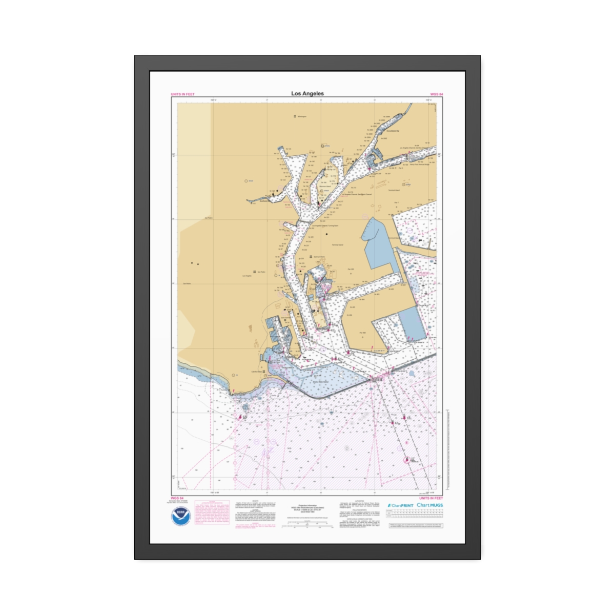
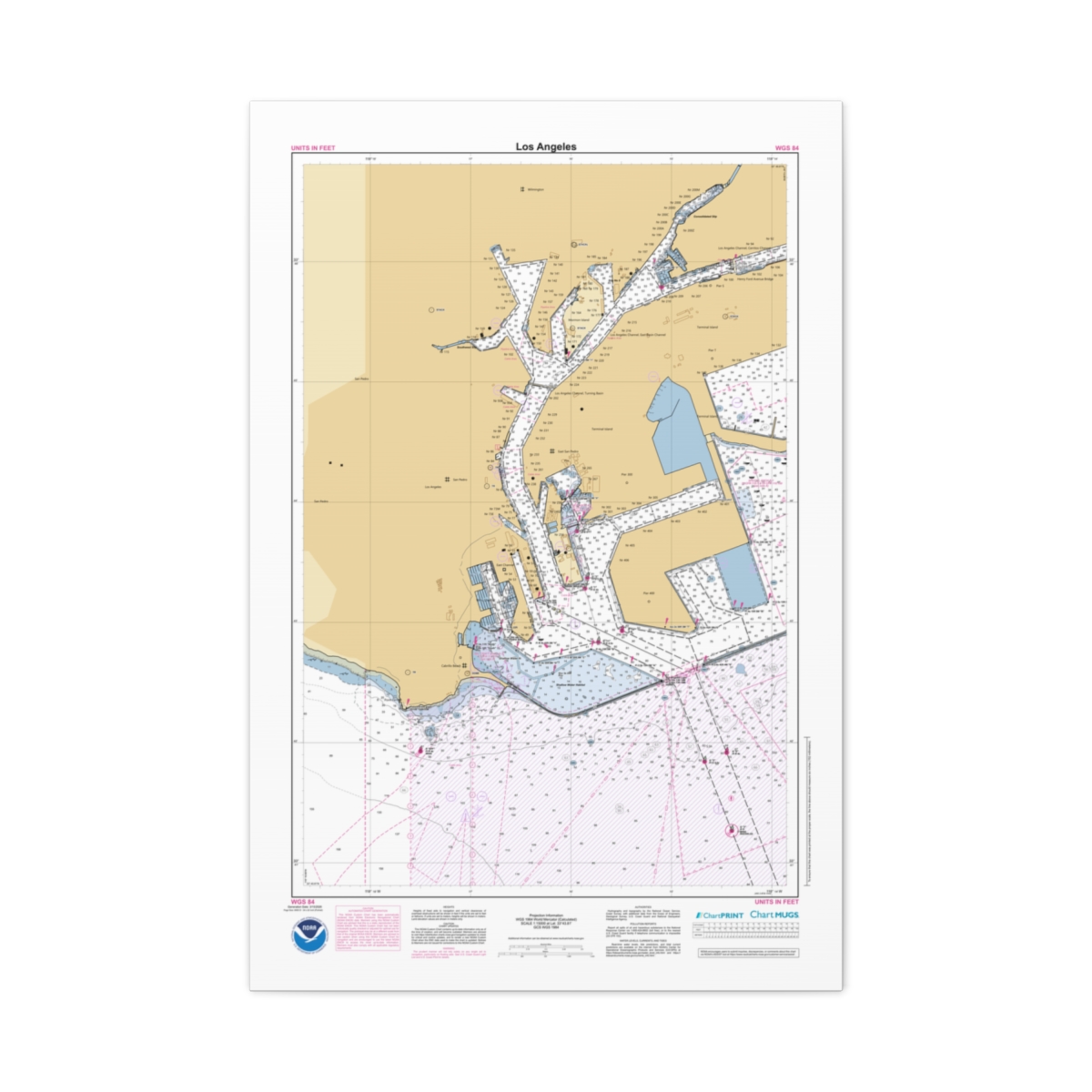
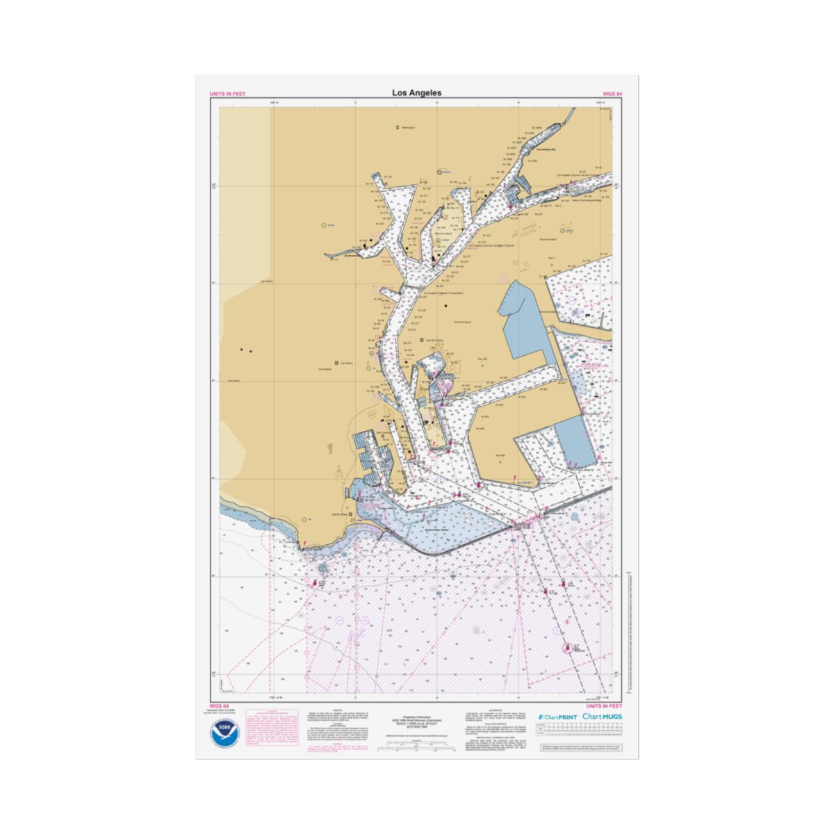
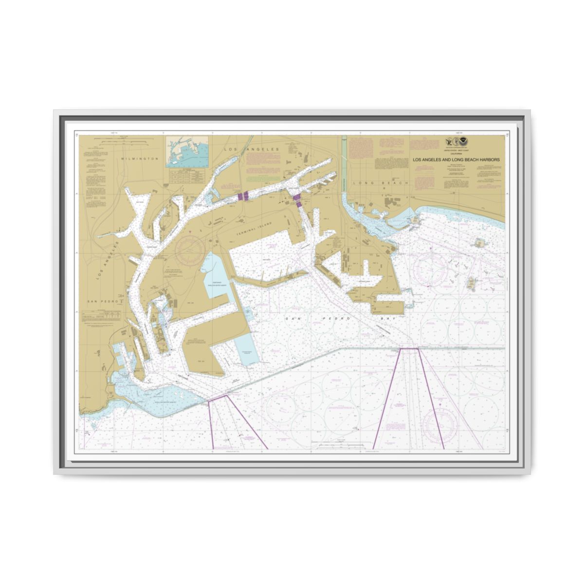
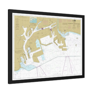
NOAA ENC Chart of Los Angeles
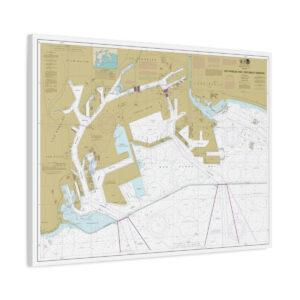
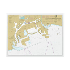
This custom NOAA nautical chart puts Los Angeles front and center at 1:15,000 scale. The chart covers harbor approaches, anchorages, and coastal waterways around Los Angeles — approach channels, depth contours, and shoreline features are clearly defined. This chart is generated from NOAA’s latest ENC data, the modern Electronic Navigational Chart format that replaced the retired Raster Nautical Chart (RNC) series in 2025. 24″ x 36″ (Vertical) format.
Gallery-Quality Floating Frame
This Los Angeles chart canvas sits inside a floating frame with a gap that gives it gallery-quality depth. Cotton-polyester composite with a proprietary coating for lasting color. Frame is FSC certified radiata pine in your choice of Black, Espresso, White, or Natural. Ready to hang with sawtooth hardware.
Four Frame Colors
Natural
Warm wood tone. Our most popular choice.
Black
Classic matte black. Sharp contrast.
Espresso
Rich dark brown. Warm sophistication.
White
Clean and bright. Modern minimal.
FSC Certified
Radiata pine from sustainably managed forests
Greenguard Gold Inks
UL certified, non-toxic, non-flammable
Sawtooth Hardware
Pre-attached, ready to hang immediately
1.25″ Depth
Gallery-quality canvas with floating gap
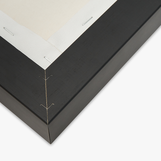
Chart Data
The Latest NOAA Chart Source
Every line, sounding, and symbol comes from official NOAA ENC data — the modern vector-based format that replaced the retired Raster Nautical Chart series.
- Chart Source: Official NOAA ENC data
- Scale: 1:15,000 — approach detail
- Print Size: 24″ x 36″ (Vertical)
- Format: Floating Frame Canvas
- Canvas: Cotton/polyester composite with proprietary coating
- Frame: FSC certified pinewood — Black, Espresso, White, or Natural
- Inks: UL Greenguard Gold certified latex
- Shipping: Free on all orders
Common Questions
Frequently Asked Questions
What frame colors are available?
What is a floating frame?
Are the inks safe for indoor use?
Is this chart suitable for navigation?
If the canvas gathers dust, wipe gently with a clean, damp cloth.
Build Another Chart
Want a different location or scale? Our chart builder covers every US waterway.
Chart Notes Preview
Los Angeles
Generation Date: 3/15/2026
Page 2
NOAA CUSTOM CHART
NOTES GEOSPATIAL DATABASE
VERSION 3.0B - 20 FEBRUARY 2025
The records of the NOAA Custom
Chart Notes Geospatial Database are
current as of February 20, 2025.
Subsequent additions and refinements
are to be expected. Please refer to
all
available
navigational
publications for complete information
about the charted area.
CAUTION
AUTOMATED CHART GENERATION
This NOAA Custom Chart has been
automatically
rendered
from
NOAA
Electronic Navigational Chart (NOAA
ENC®) data. Mariners using this NOAA
Custom Chart are advised that this is
a static reproduction of the NOAA
ENC®. This NOAA Custom Chart has not
been individually quality checked or
adjusted
for
optimal
use
for
navigation. The portrayal may be at a
different scale from that of the
original NOAA ENC®. Mariners are
advised to use caution when using
this NOAA Custom Chart for navigation
and are encouraged to use the latest
NOAA ENC® to access the most up-to-
date information. Mariners must also
comply with all applicable regulatory
requirements.
CAUTION
CHART UPDATES
This NOAA Custom Chart contains up-
to-date information only as of the
time of creation, and will become
outdated. Mariners are advised to
visit
https://
distribution.charts.noaa.gov/
navigation-updates/
to
check
for
critical and routine updates, and to
render a new NOAA Custom Chart when
the ENC data used to make the chart
is updated. Notices to Mariners are
not issued for corrections to this
NOAA Custom Chart.
HEIGHTS
Heights of fixed aids to navigation
and vertical clearances of overhead
obstructions will be shown in feet if
the units are set to feet or fathoms.
If units are set to meters, heights
will
be
shown
in
meters.
Land
elevation values are shown in meters
only.
AUTHORITIES
Hydrography and topography by the
National Ocean Service, Coast Survey,
with additional data from the Corps
of Engineers, Geological Survey, U.S.
Coast Guard and National Geospatial-
Intelligence Agency.
WATER LEVELS, CURRENTS, AND TIDES
Real-time
water
levels,
tide
predictions,
and
tidal
current
predictions are available on the
internet
from
NOAA’s
Center
for
Operational
Oceanographic
Products
and Services (CO-OPS) at https://
tidesandcurrents.noaa.gov/
water_level_info.html
and
https://
tidesandcurrents.noaa.gov/
currents_info.html .
COMMENTS REQUESTED
NOAA encourages users to submit
inquiries, discrepancies, or comments
about this chart via NOAA's ASSIST
tool
at
https://
nauticalcharts.noaa.gov/customer-
service/assist/ .
ABBREVIATIONS
For complete list of Symbols and
Abbreviations, see Chart No. 1.
Los Angeles
Generation Date: 3/15/2026
Page 3
POLLUTION REPORTS
Report all spills of oil and
hazardous substances to the National
Response Center via 1-800-424-8802
(toll free), or to the nearest U.S.
Coast Guard facility if telephone
communication is impossible (33 CFR
153).
AIDS TO NAVIGATION
Consult U.S. Coast Guard Light List
for
supplemental
information
concerning aids to navigation.
RADAR REFLECTORS
Radar reflectors have been placed
on many floating aids to navigation.
Individual
radar
reflector
identification on these aids has been
omitted from this chart.
WARNING
The prudent mariner will not rely
solely
on
any
single
aid
to
navigation, particularly on floating
aids. See U.S. Coast Guard Light List
and U.S. Coast Pilot for details.
ADDITIONAL INFORMATION
Additional information can be
obtained
at
www.nauticalcharts.noaa.gov
SUPPLEMENTAL INFORMATION
Consult U.S. Coast Pilot 7 for
important supplemental information.
Refer to charted regulation section
numbers.
SOUNDING DATUM
Soundings referred to Mean Lower
Low Water (MLLW).
VERTICAL DATUM
Overhead clearances are referred to
Mean High Water (MHW).
NOTE A
Navigation
regulations
are
published in Chapter 2, U.S. Coast
Pilot 7. Additions or revisions to
Chapter
2
are
published
in
the
Notices
to
Mariners.
Information
concerning the regulations may be
obtained
at
the
Office
of
the
Commander, 11th Coast Guard District
in Alameda, CA or at the Office of
the
District
Engineer,
Corps
of
Engineers in Los Angeles, CA.
Refer to charted regulation section
numbers.
COLREGS DEMARCATION LINE
The Inland Navigational Rules Act
of 1980 is in effect for vessels
transiting this area. The seaward
boundaries of this area are the
COLREGS demarcation lines. In the
area
seaward
of
the
COLREGS
demarcation
lines,
vessels
are
governed by COLREGS: International
Regulations for Preventing Collisions
at Sea, 1972. The COLREGS demarcation
line is defined in COLREGS 33 CFR
80.1114c.
MINERAL DEVELOPMENT STRUCTURES
Obstruction lights and sound (fog)
signals
are
required
for
fixed
mineral
development
structures,
subject to approval by the District
Commander, U.S. Coast Guard (33 CFR
67).
Los Angeles
Generation Date: 3/15/2026
Page 4
VESSEL TRAFFIC MANAGEMENT SYSTEM
(VTMS)
The Vessel Traffic Service of Los
Angeles-Long Beach, jointly operated
by the U.S. Coast Guard and Marine
Exchange, has been established within
the approaches to San Pedro Bay. The
working frequency for the VTS is
channel 14 VHF/FM (156.7 MHz) and the
call sign is “San Pedro Traffic.”
Upon entering the VTS area, within a
25 nautical mile radius of Pt. Fermín
(LAT 33°42.3’N, LONG 118°17.6’W), all
inbound
vessels
shall
report
on
channel 14 their vessel name, call
sign, position, course and speed,
destination,
estimated
time
of
arrival to their destination, and
whether or not their vessel will be
taking on a pilot. Outbound vessels
shall report 15 minutes prior to
reaching the breakwater. To obtain
information on the movement of deep
draft vessels inside the Federal
Breakwater, contact the Los Angeles
Pilot Station on channel 73 (156.675
MHz)/phone 310-732-3805 or Long Beach
Pilot Station on channel 74 (156.6
MHz)/phone 562-432-0664.
TRAFFIC SEPARATION SCHEME
One-way
traffic
lanes
are
RECOMMENDED for use by all vessels
traveling
between
the
points
involved. They have been designed to
aid in the prevention of collisions
at the approaches to major harbors
and along heavily traveled coastal
waters, but are not intended in any
way to supersede or to alter the
applicable
Rules
of
the
Road.
Separation zones are intended to
separate inbound and outbound traffic
and to be free of ship traffic.
Separation zones should not be used
except for crossing purposes. When
crossing traffic lanes and separation
zones use extreme caution.
PRECAUTIONARY AREA
A precautionary area has been
established in the Los Angeles - Long
Beach
area.
Large
vessels
are
maneuvering to embark or disembark
pilots, and to enter or depart the
traffic separation system. It is
recommended
vessels
proceed
with
extreme caution in this area. Vessels
are prohibited from anchoring in the
precautionary
area
except
in
designated anchorages (33 CFR 110.214
- see Note A).
CAUTION
Temporary changes or defects in
aids to navigation are not indicated
on this chart. See Local Notice to
Mariners.
CAUTION
LIMITATIONS ON THE
USE OF RADIO SIGNALS
Limitations on the use of radio
signals as aids to marine navigation
can be found in the U.S. Coast Guard
Light Lists and National Geospatial-
Intelligence Agency Publication 117.
Radio direction-finder bearings to
commercial broadcasting stations are
subject to error and should be used
with caution.
Los Angeles
Generation Date: 3/15/2026
Page 5
CAUTION
SUBMERGED CABLES AND PIPELINES
Additional uncharted submarine
pipelines and submarine cables may
exist within the area of this chart.
Not
all
submarine
pipelines
and
submarine cables are required to be
buried,
and
those
that
were
originally buried may have become
exposed. Mariners should use extreme
caution when operating vessels in
depths of water comparable to their
draft in areas where pipelines and
cables may exist, and when anchoring,
dragging or trawling.
Covered wells may be marked by
lighted or unlighted buoys.
CAUTION
The Los Angeles and Long Beach main
channels
are
considered
narrow
channels. Vessels less than 20 meters
in length, sailing vessels, vessels
engaged in fishing, or any vessel
attempting to cross these channels
shall not impede a vessel that can
only safely navigate within a narrow
channel as per Inland Navigation
Rules, Rule 9. To obtain information
on the movement of deep draft vessels
inside Federal Breakwater contact the
Los Angeles Pilot Station on channel
73 (156.675 MHz) / ph 310-732-3805
or
Long
Beach
Pilot
Station
on
channel
74
(156.6
MHz)
/
ph
562-432-0664.
CAUTION
Vessels should not enter the Pilot
Operating Area unless entering or
departing Los Angeles Channel.
CAUTION
There are rock outcroppings in
northern General Anchorage N. Use
caution.
CAUTION
USACE conducts hydrographic surveys
to
monitor
navigation
conditions.
These surveys are not intended to
detect underwater features. Uncharted
features
hazardous
to
surface
navigation are not expected but may
exist in federal channels. For more
information
visit
https://
navigation.usace.army.mil/Survey/
Hydro.
CAUTION
Improved channels are subject to
shoaling, particularly at the edges.
Los Angeles
Generation Date: 3/15/2026
Page 6
NOTE Z
NO-DISCHARGE ZONE, 40 CFR 140
Under the Clean Water Act, Section
312, all vessels operating within a
No-Discharge
Zone
(NDZ)
are
completely
prohibited
from
discharging any sewage, treated or
untreated,
into
the
waters.
All
vessels with an installed marine
sanitation device (MSD) that are
navigating,
moored,
anchored,
or
docked within a NDZ must have the MSD
disabled to prevent the overboard
discharge
of
sewage
(treated
or
untreated) or install a holding tank.
Regulations for the NDZ are contained
in the U.S. Coast Pilot. Additional
information
concerning
the
regulations and requirements may be
obtained
from
the
Environmental
Protection
Agency
(EPA)
website:
https://www.epa.gov/vessels-marinas-
and-ports .
SUBMERGED SUBMARINE OPERATING AREAS
Submerged submarine operations are
conducted at various times in the
waters
contained
on
this
chart.
Proceed with caution.
ANCHORAGE BERTHS
The anchorage berths are for the
convenience of the Captain of the
Port and/or port pilots. Anchorages
outside the federal breakwater are
assigned by the Captain of the Port
through VTMS. Anchorages inside the
breakwater
are
assigned
by
the
applicable port pilot. The Delta
anchorages are for the use of the
U.S. Navy and U.S. Coast Guard for
explosive loadings.
OUTSIDE BREAKER ANCHORAGE AREA G
Commercial
anchorage,
33
CFR
110.214. Vessels are prohibited from
entering Anchorage G unless bound for
a berth in that anchorage.
BERTH NUMBERS
The numbers on land along the
waterfront are berth numbers.
SUBMARINE PIPELINES AND CABLES
Uncharted submarine pipelines and
cables may exist in the vicinity of
oil well structures, and between such
structures
and
the
shoreline.
Mariners should use caution when
anchoring.
NOAA WEATHER RADIO BROADCASTS
The NOAA Weather Radio station
listed
below
provides
continuous
weather
broadcasts.
The
reception
range is typically 20 to 40 nautical
miles from the antenna site, but can
be as much as 100 nautical miles for
stations at high elevations.
Los Angeles, CA KWO-37 162.550 MHz
NOAA WEATHER RADIO BROADCASTS
The NOAA Weather Radio station
listed
below
provides
continuous
weather
broadcasts.
The
reception
range is typically 20 to 40 nautical
miles from the antenna site, but can
be as much as 100 nautical miles for
stations at high elevations.
Santa Ana, CA WWG-21 162.450 MHz
NOAA WEATHER RADIO BROADCASTS
The NOAA Weather Radio station
listed
below
provides
continuous
weather
broadcasts.
The
reception
range is typically 20 to 40 nautical
miles from the antenna site, but can
be as much as 100 nautical miles for
stations at high elevations.
Victorville, CA WXM-66 162.500 MHz
Reviews
There are no reviews yet.