


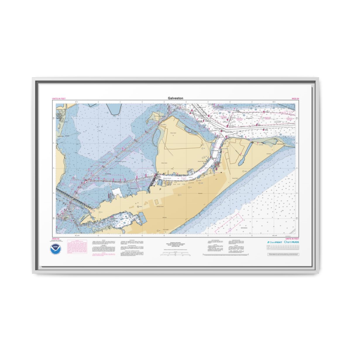
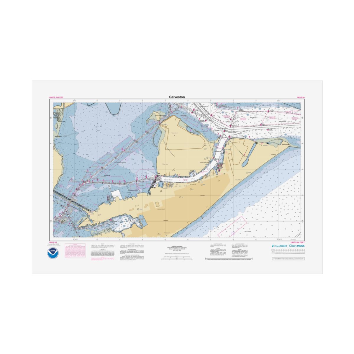
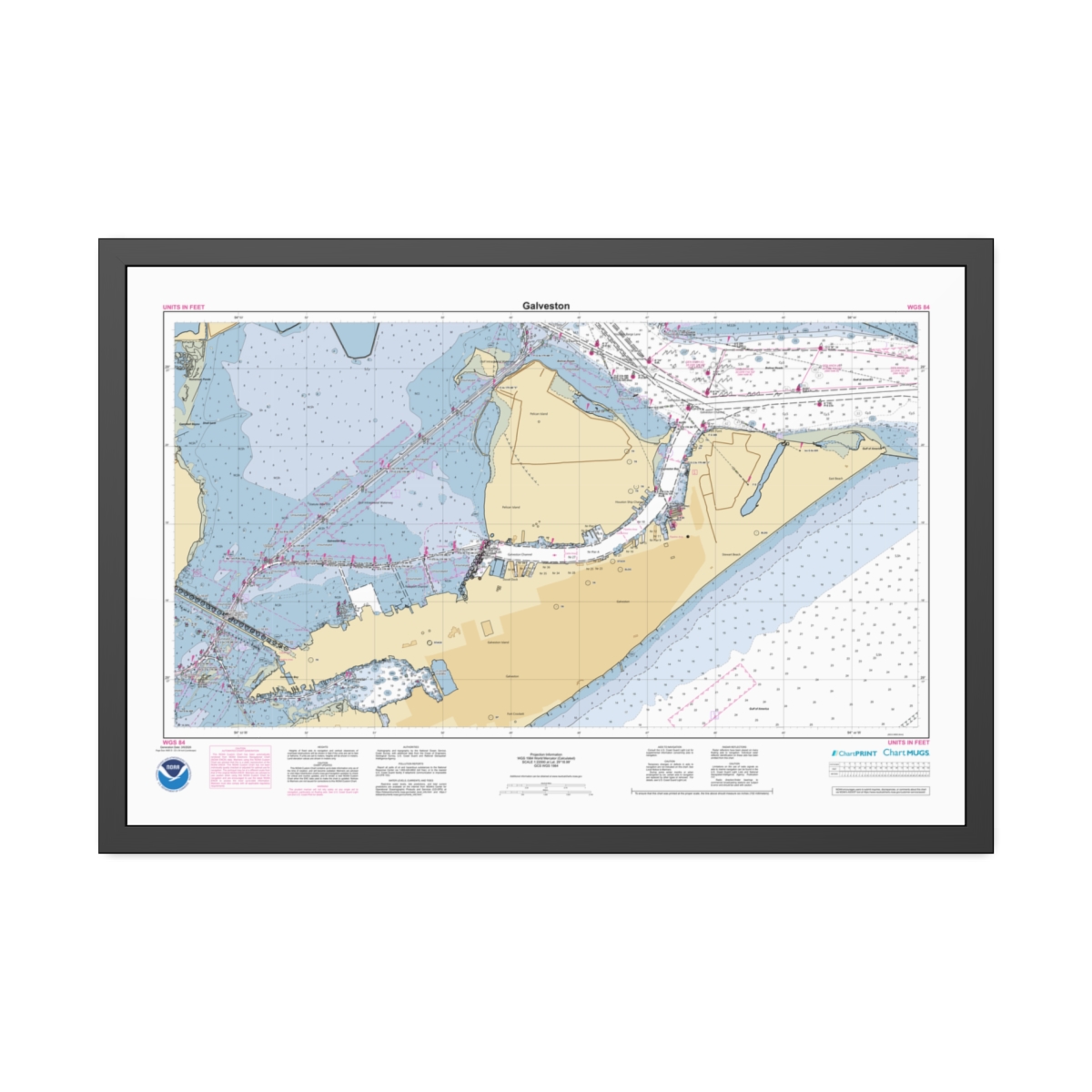
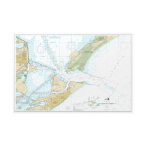
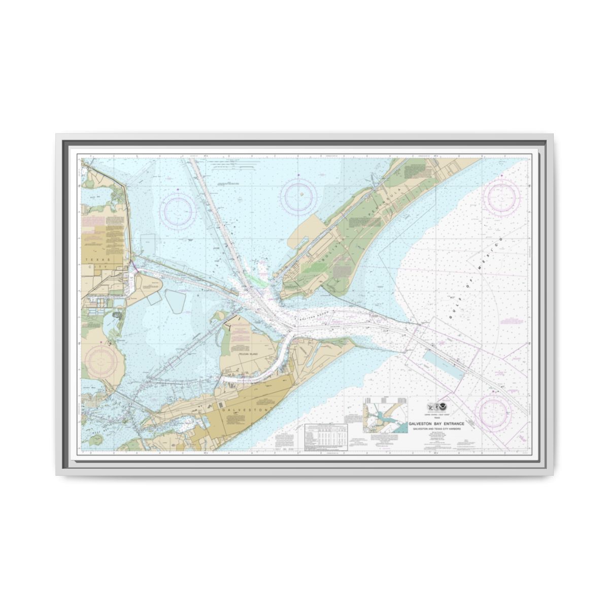
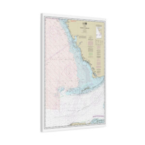
NOAA ENC Chart of Galveston
This custom NOAA nautical chart puts Galveston front and center at 1:22,000 scale. A working-distance view of Galveston showing harbor entrances, navigation channels, and the coastal waters just offshore. This chart is generated from NOAA’s latest ENC data, the modern Electronic Navigational Chart format that replaced the retired Raster Nautical Chart (RNC) series in 2025. 36″ x 24″ (Horizontal) format.
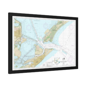
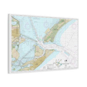
Gallery-Wrapped Nautical Chart
Your custom Galveston nautical chart on cotton-polyester composite canvas, gallery-wrapped on 1.25″ radiata pine stretcher bars from FSC certified renewable forests. Back hanging hardware and soft rubber dots pre-installed. Frameless by design — clean edges, modern look, ready to hang.
FSC Certified Pine
1.25″ radiata pine from renewable forests
Greenguard Gold Inks
UL certified, non-toxic, non-flammable
Back Hanging Hardware
Pre-installed with rubber wall-protection dots
No Frame Needed
Gallery-wrapped edges, clean frameless look
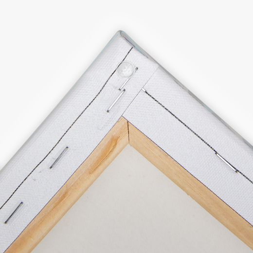
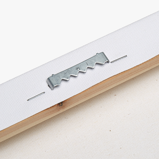
Chart Data
The Latest NOAA Chart Source
This nautical chart canvas print of Galveston is built from NOAA’s current Electronic Navigational Chart data — more precise and up-to-date than the traditional paper charts it replaced.
- Chart Source: Official NOAA ENC data
- Scale: 1:22,000 — approach detail
- Print Size: 36″ x 24″ (Horizontal)
- Format: Wrapped Canvas
- Canvas: Cotton/polyester composite, 1.25″ stretched
- Frame: Radiata pine from FSC certified forests
- Inks: UL Greenguard Gold certified latex
- Shipping: Free on all orders
FAQ
Questions & Answers
Does it need a frame?
What are the rubber dots for?
Are the inks safe for indoor use?
Is this chart suitable for navigation?
If the canvas gathers dust, wipe gently with a clean, damp cloth.
Build Another Chart
Want a different location or scale? Our chart builder covers every US waterway.
Chart Notes Preview
Galveston
Generation Date: 3/6/2026
Page 2
NOAA CUSTOM CHART
NOTES GEOSPATIAL DATABASE
VERSION 3.0B - 20 FEBRUARY 2025
The records of the NOAA Custom
Chart Notes Geospatial Database are
current as of February 20, 2025.
Subsequent additions and refinements
are to be expected. Please refer to
all
available
navigational
publications for complete information
about the charted area.
CAUTION
AUTOMATED CHART GENERATION
This NOAA Custom Chart has been
automatically
rendered
from
NOAA
Electronic Navigational Chart (NOAA
ENC®) data. Mariners using this NOAA
Custom Chart are advised that this is
a static reproduction of the NOAA
ENC®. This NOAA Custom Chart has not
been individually quality checked or
adjusted
for
optimal
use
for
navigation. The portrayal may be at a
different scale from that of the
original NOAA ENC®. Mariners are
advised to use caution when using
this NOAA Custom Chart for navigation
and are encouraged to use the latest
NOAA ENC® to access the most up-to-
date information. Mariners must also
comply with all applicable regulatory
requirements.
CAUTION
CHART UPDATES
This NOAA Custom Chart contains up-
to-date information only as of the
time of creation, and will become
outdated. Mariners are advised to
visit
https://
distribution.charts.noaa.gov/
navigation-updates/
to
check
for
critical and routine updates, and to
render a new NOAA Custom Chart when
the ENC data used to make the chart
is updated. Notices to Mariners are
not issued for corrections to this
NOAA Custom Chart.
HEIGHTS
Heights of fixed aids to navigation
and vertical clearances of overhead
obstructions will be shown in feet if
the units are set to feet or fathoms.
If units are set to meters, heights
will
be
shown
in
meters.
Land
elevation values are shown in meters
only.
AUTHORITIES
Hydrography and topography by the
National Ocean Service, Coast Survey,
with additional data from the Corps
of Engineers, Geological Survey, U.S.
Coast Guard and National Geospatial-
Intelligence Agency.
WATER LEVELS, CURRENTS, AND TIDES
Real-time
water
levels,
tide
predictions,
and
tidal
current
predictions are available on the
internet
from
NOAA’s
Center
for
Operational
Oceanographic
Products
and Services (CO-OPS) at https://
tidesandcurrents.noaa.gov/
water_level_info.html
and
https://
tidesandcurrents.noaa.gov/
currents_info.html .
COMMENTS REQUESTED
NOAA encourages users to submit
inquiries, discrepancies, or comments
about this chart via NOAA's ASSIST
tool
at
https://
nauticalcharts.noaa.gov/customer-
service/assist/ .
ABBREVIATIONS
For complete list of Symbols and
Abbreviations, see Chart No. 1.
Galveston
Generation Date: 3/6/2026
Page 3
POLLUTION REPORTS
Report all spills of oil and
hazardous substances to the National
Response Center via 1-800-424-8802
(toll free), or to the nearest U.S.
Coast Guard facility if telephone
communication is impossible (33 CFR
153).
AIDS TO NAVIGATION
Consult U.S. Coast Guard Light List
for
supplemental
information
concerning aids to navigation.
RADAR REFLECTORS
Radar reflectors have been placed
on many floating aids to navigation.
Individual
radar
reflector
identification on these aids has been
omitted from this chart.
WARNING
The prudent mariner will not rely
solely
on
any
single
aid
to
navigation, particularly on floating
aids. See U.S. Coast Guard Light List
and U.S. Coast Pilot for details.
ADDITIONAL INFORMATION
Additional information can be
obtained
at
www.nauticalcharts.noaa.gov
SUPPLEMENTAL INFORMATION
Consult U.S. Coast Pilot 5 for
important supplemental information.
Refer to charted regulation section
numbers.
SOUNDING DATUM
Soundings referred to Mean Lower
Low Water (MLLW).
VERTICAL DATUM
Overhead clearances are referred to
Mean High Water (MHW).
NOTE A
Navigation
regulations
are
published in Chapter 2, U.S. Coast
Pilot 5. Additions or revisions to
Chapter
2
are
published
in
the
Notices
to
Mariners.
Information
concerning the regulations may be
obtained
at
the
Office
of
the
Commander, 8th Coast Guard District
in New Orleans, LA or at the Office
of the District Engineer, Corps of
Engineers in Galveston, TX.
Refer to charted regulation section
numbers.
Galveston
Generation Date: 3/6/2026
Page 4
HURRICANES AND TROPICAL STORMS
Hurricanes, tropical storms and
other
major
storms
may
cause
considerable
damage
to
marine
structures, aids to navigation and
moored
vessels,
resulting
in
submerged
debris
in
unknown
locations. Charted soundings, channel
depths and shoreline may not reflect
actual
conditions
following
these
storms. Fixed aids to navigation may
have been damaged or destroyed. Buoys
may
have
been
moved
from
their
charted
positions,
damaged,
sunk,
extinguished
or
otherwise
made
inoperative. Mariners should not rely
upon the position or operation of an
aid
to
navigation.
Wrecks
and
submerged obstructions may have been
displaced
from
charted
locations.
Pipelines may have become uncovered
or moved. Mariners are urged to
exercise extreme caution and are
requested
to
report
aids
to
navigation discrepancies and hazards
to navigation to the nearest United
States Coast Guard unit.
MINERAL DEVELOPMENT STRUCTURES
Obstruction lights and sound (fog)
signals
are
required
for
fixed
mineral
development
structures,
subject to approval by the District
Commander, U.S. Coast Guard (33 CFR
67).
VESSEL TRAFFIC SERVICES (VTS)
The U.S. Coast Guard operates a
mandatory
Vessel
Traffic
Services
(VTS)
system
in
the
Hudson,
Galveston, and Texas City waterways.
Vessel
operating
procedures
and
designated radiotelephone frequencies
are published in 33 CFR 161, the U.S
Coast Pilot, and/or the VTS User’s
Manual. Mariners should consult these
sources for applicable rules and
reporting
requirements.
Although
mandatory
VTS
participation
is
limited to the navigable waters of
the United States, certain vessels
are encouraged or may be required, as
a condition of port entry, to report
beyond
this
area
to
facilitate
advance
vessel
traffic
management
within the VTS area.
INTRACOASTAL WATERWAY AIDS
The U.S. Aids to Navigation System
is designed for use with nautical
charts, and the exact meaning of an
aid to navigation may not be clear
unless
the
appropriate
chart
is
consulted. Aids to navigation marking
the
Intracoastal
Waterway
exhibit
unique yellow symbols to distinguish
them
from
aids
marking
other
waterways.
When
following
the
Intracoastal Waterway westward from
Carrabelle, FL to Brownsville, TX,
aids with yellow triangles should be
kept on the starboard side of the
vessel and aids with yellow squares
should be kept on the port side of
the vessel. A horizontal yellow band
provides no lateral information, but
simply identifies aids to navigation
as marking the Intracoastal Waterway.
CAUTION
Temporary changes or defects in
aids to navigation are not indicated
on this chart. See Local Notice to
Mariners.
CAUTION
LIMITATIONS ON THE
USE OF RADIO SIGNALS
Limitations on the use of radio
signals as aids to marine navigation
can be found in the U.S. Coast Guard
Light Lists and National Geospatial-
Intelligence Agency Publication 117.
Radio direction-finder bearings to
commercial broadcasting stations are
subject to error and should be used
with caution.
Galveston
Generation Date: 3/6/2026
Page 5
CAUTION
BASCULE BRIDGES
For bascule bridges, whose spans do
not open to a full upright or
vertical position, unlimited vertical
clearance is not available for the
entire charted horizontal clearance.
CAUTION
SUBMERGED CABLES AND PIPELINES
Additional uncharted submarine
pipelines and submarine cables may
exist within the area of this chart.
Not
all
submarine
pipelines
and
submarine cables are required to be
buried,
and
those
that
were
originally buried may have become
exposed. Mariners should use extreme
caution when operating vessels in
depths of water comparable to their
draft in areas where pipelines and
cables may exist, and when anchoring,
dragging or trawling.
Covered wells may be marked by
lighted or unlighted buoys.
CAUTION
Open bascule overhangs Galveston
Channel.
HOUSTON SHIP CHANNEL
Large
vessels
traversing
the
Houston Ship Channel can cause swells
engulfing the shoals alongside the
channel.
Small
craft
should
use
extreme caution when operating in
these areas.
CAUTION
Stakes, piles and platforms, some
submerged, may exist between charted
piling
and
platforms
along
the
maintained
channels.
Piles
and
platforms are not shown where they
interfere with a light symbol.
CAUTION
USACE conducts hydrographic surveys
to
monitor
navigation
conditions.
These surveys are not intended to
detect underwater features. Uncharted
features
hazardous
to
surface
navigation are not expected but may
exist in federal channels. For more
information
visit
https://
navigation.usace.army.mil/Survey/
Hydro.
CAUTION
Improved channels are subject to
shoaling, particularly at the edges.
OBSTRUCTIONS
Numerous stakes may exist between
piling and platforms along Houston
Ship Channel. Pilings, platforms, and
stakes may be submerged.
MOORING BUOYS
Mooring buoys are located north of
the
Galveston-Freeport
Cutoff
Channel.
NOAA WEATHER RADIO BROADCASTS
The NOAA Weather Radio station
listed
below
provides
continuous
weather
broadcasts.
The
reception
range is typically 20 to 40 nautical
miles from the antenna site, but can
be as much as 100 nautical miles for
stations at high elevations.
Galveston, TX KHB-40 162.550 MHz
Reviews
There are no reviews yet.